


Topobot app for iPhone and iPad
TopoBot is a Land Surveying application which empowers all land owners in Romania to manage their properties and to communicate with the local administration, in order to speed up the process of free land registration.
TopoBot offers the following advantages:
1. Measuring
• You can measure either parcels or points depending on your needs;
• The application uses the Romanian coordinates system (Stereographic 1970) for all calculations;
• If GPS positioning is not precise enough, the application offers digitizing capabilities based on up-to-date Google Maps images;
• It allows you to measure land plots and points, even if the device has no Internet connection.
2. Finding
• Now you can find any point or real estate parcel located in Romania just by inserting the coordinates in the app;
• The application offers real time directions to the selected location, enabling the user to identify the boundaries of real estate properties or the location of points in the field;
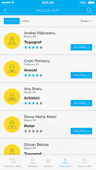
3. Experts
• The application offers easy access to 4 types of experts: Land Surveyors, Lawyers, Architects and Notaries, enabling the user to filter based on the types and counties.
4. Sharing
• Now you can easily share a location with your friends or with your work colleges, its enough to enter their e-mail address and all the information of your property will be shared to them.
5. Submitting information to the Town Hall
• It automatically determines in which County and City the property is located in;
• The application encourages Land Registration in Romania and the national project of General Cadastre;
• With TopoBot, you can now measure your land and automatically share it with the local administration, in order to request free land registration.
6. It also protects the user
• It encourages the users to make their parcels public, in order to provide more transparency;
• It only allows users to measure points in a radius of 20 m from the current location, in order to encourages only field measurements;
• The application allows any user to report any property that is public and that he considers to be incorrectly located.
TopoBot is an application aimed both at every day users and GIS professionals, that want a powerful measuring solution and the capability to share their measurements with friends, colleges or the local administration.